66% of Medicare Inpatient Rates Are Geography Adjusted — Are Your Zip Maps Aligned?
TL;DR
- Analytics layer: ZCTAs = stable 2020 shapes with annual ACS attribute updates.
- Payment layer: Hospital wage index by CBSA; clinician GPCIs by CMS payment localities. ZIPs mainly route addresses to localities via CMS’ crosswalk.
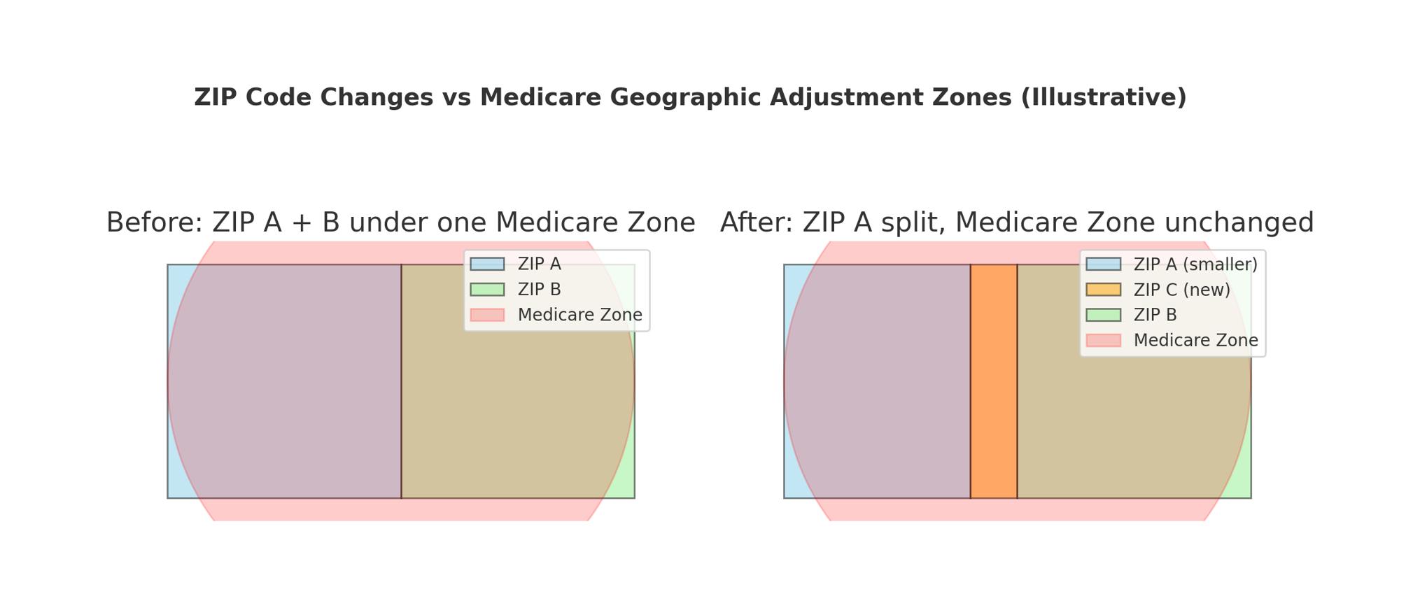
- Mismatch risk: USPS can add/change ZIPs mid-decade; ZCTA shapes won’t reflect that until the next Census.
Why “ZIP-level” ≠ “payment geography”
Most teams say “ZIP-level” and visualize ZCTAs (Census-built approximations of USPS ZIP areas). ZCTA shapes are re-delineated with each decennial Census (most recently for 2020) and then held fixed; the ACS refreshes the data inside those shapes every year. That’s perfect for population/SDOH dashboards—but it’s not how Medicare sets rates.
What actually moves Medicare dollars
- Hospitals (IPPS): The Hospital Wage Index adjusts only the labor portion of the base rate, and for FY 2026 CMS finalized a national labor-related share of 66%. The wage index is computed by labor market (CBSA) and updated annually. Not ZCTA-based.
- Physicians/Clinicians (PFS): GPCIs (work, practice expense—including wages & rent—and malpractice) apply by CMS payment locality (statewide or county-group areas).
Operationally, CMS and its MACs maintain a ZIP→locality crosswalk to map practice/street addresses into the right payment locality for claims routing—and USPS posts ZIP changes throughout the year in Postal Bulletins.
The mismatch to watch
- Analytics (ZCTAs + ACS): stable shapes; annually refreshed attributes.
- Payments (CBSA/locality + crosswalk): dollars follow labor markets & localities; ZIPs just route the address to one.
When you model demand or SDOH at “ZIP level” in ZCTAs but route claims with current USPS ZIPs, your denominators and your dollars may be using different shapes.
Practical fixes
- Separate the layers. Use ZCTAs/tracts for population & equity analyses; use CBSA/locality geographies for reimbursement modeling.
- Maintain crosswalks. Keep the CMS ZIP→locality file current; monitor USPS ZIP updates (Postal Bulletins).
- Label vintages. Stamp dashboards with the ZCTA vintage (2020) and ACS year so users know when “ZIP-level” numbers are really ZCTA-based estimates.

Glossary: ZIPs, ZCTAs & Medicare geographies
- USPS ZIP Code
- Mail routing code; can change mid-decade; appears on claims and provider addresses.
- ZCTA (Census)
- Polygon approximation of ZIP areas; redrawn only at each decennial Census; ACS updates attributes annually
- ACS (American Community Survey
- Annual demographic/economic estimates published by Census, tied to fixed ZCTA boundaries between censuses.
- CBSA (Core-Based Statistical Area)
- Metro/micro labor-market geography used for the hospital wage index (IPPS). Not ZIP/ZCTA based.
- CMS Payment Locality
- Statewide or county-group areas used for physician/clinician payment adjustments (GPCIs) under the PFS.
- GPCI
- Geographic Practice Cost Indices adjusting work, practice expense (incl. wages & rent), and malpractice.
- Hospital Wage Index
- Adjustment applied to the labor-related share of the IPPS base rate by CBSA (updated annually).
- ZIP → Locality Mapping
- CMS file that maps a street/practice ZIP to the correct payment locality for claims routing.
- CMS file that maps a street/practice ZIP to the correct payment locality for claims routing.
#Medicare #CMS #HealthcarePayments #GeospatialAnalytics #HospitalWageIndex #GPCI